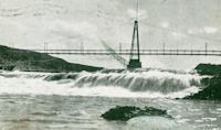
This is a single suspension bridge from the Bridgemeister historical inventory of suspension bridges.
Black Eagle Falls
Great Falls and Black Eagle, Montana, USA - Missouri River
| Bridgemeister ID: | 6358 (added 2021-07-26) |
| Name: | Black Eagle Falls |
| Location: | Great Falls and Black Eagle, Montana, USA |
| Crossing: | Missouri River |
| At or Near Feature: | Eagle Falls, Black Eagle Dam |
| Coordinates: | 47.519905 N 111.262229 W |
| Maps: | Acme, GeoHack, Google, OpenStreetMap |
| Use: | Footbridge |
| Status: | Destroyed, June 6, 1908 |
| Main Cables: | Wire (steel) |
| Main Span: | 1 |
| Side Span: | 1 |
Notes:
- Completed early 1890s.
- 1908, June: Destroyed by flood.
External Links:
- Black Eagle Dam - Wikipedia. From the article (retrieved 2021): "A 200-foot-long (61 m), 10-foot-wide (3.0 m) pedestrian suspension bridge ran from the bluffs above each powerhouse over the river." However, historic images of the bridge show it wa significantly longer with main and side spans of roughly 400 and 200 feet respectively.
Image Sets:

Patrick S. O'Donnell contributed to the information and/or images for this bridge.
Do you have any information or photos about this bridge that you would like to share? Please email david.denenberg@bridgemeister.com.
Mail | Facebook | X (Twitter) | Bluesky