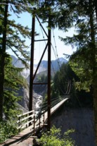
This is a single suspension bridge from the Bridgemeister historical inventory of suspension bridges.
1995: Tahoma Creek
Mt. Rainier National Park, Washington, USA - Tahoma Creek
| Bridgemeister ID: | 1433 (added 2004-07-30) |
| Year Completed: | 1995 |
| Name: | Tahoma Creek |
| Location: | Mt. Rainier National Park, Washington, USA |
| Crossing: | Tahoma Creek |
| At or Near Feature: | Wonderland Trail |
| Coordinates: | 46.80479 N 121.84812 W |
| Maps: | Acme, GeoHack, Google, OpenStreetMap |
| Use: | Footbridge |
| Status: | In use (last checked: 2006) |
| Main Cables: | Wire (steel) |
| Suspended Spans: | 1 |
| Main Span: | 1 x 61.9 meters (203 feet) estimated |
Notes:
- Damaged by flooding, November 2006. From a News Tribune (Tacoma, Washington) article on June 11, 2007: "Trail crews last week discovered that supporting cables at one end of the suspension bridge may have been weakened by flooding last November."
- Replaced a drooping catwalk-style suspension bridge that was anchored on different foundations still present at the bridge site. Both bridges appear to have coexisted for some time around 1995.
Image Sets:

Do you have any information or photos about this bridge that you would like to share? Please email david.denenberg@bridgemeister.com.
Mail | Facebook | X (Twitter) | Bluesky